When skiers use the phrase “earn your turns” they are talking about hiking to a snow-covered section of mountain that cannot be accessed by a chairlift in order to ski it. The phrase that kept coming to me during this hike was, “earn the burn.” As in, burn in the legs.
Let me remind you, I am hiking the trails of neighboring South Mountain to get my legs in shape for a May 2014 hike to the bottom of the Grand Canyon, and back out. If you’re looking to get your legs in shape, burn is good – and so is this hike.
I have not verified this point yet, but I would be willing to bet that this is the only trail in Arizona that leads you through a window of a burnt down structure, as you seen in the pictures below. This spot is known as Lost Ranch. It’s about a mile into the hike from the trail head, and where all the fun begins.


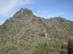
From here, you hike down through a pretty deep wash, then it’s all uphill for about another mile until you connect with National Trail. At this point, you hook a right and head east on National until it connects with Pyramid Trail about four miles later. If you’re in for a little more elevation gain, take an extra ten minutes and hike up Goat Hill for an outstanding view in all directions from 2,504 feet above sea level.


When I hiked it (January 2014), I did not encounter another person on that entire stretch. Once you connect to Pyramid Trail, you do a virtual about-face and head west about 1.5 miles before reaching what many consider the top of the trail.
Here is where I discovered my first petroglyph on South Mountain. I hear there are numerous petroglyph sites scattered throughout the park.

Speaking from experience, the descent down the face of Pyramid Trail can be challenging, but nowhere near as tough as the hike up it.
Hike details:
- Trail: Lost Ranch – National – Pyramid
- Length: 9 mile loop
- Time: 3.5 hours
- Elevation gain: negligible
- Difficulty: 1,270 (includes Goat Hill)
- Date hiked: January 11, 2014
*Rough estimates. I don’t do GPS.


