Cruising Arizona’s Apache Trail


I had a free weekend in mid-January 2014, so my oldest daughter and I took to Arizona’s open roads and checked the Apache Trail off our Arizona Bucket List. The roughly 5-hour loop begins just north of the town of Apache Junction on the eastern edge of Phoenix metro. Most of the drive consists of fairly navigable two-lane blacktop. It’s the 25 or so miles of dusty, washboard road that will keep me from rushing back.

Prior to moving to Phoenix in 2012, I spent 17 years in the Denver – Boulder area of Colorado and did plenty of driving in the Rocky Mountains. So, I am fairly adept at handling steep, winding roads. However, I wasn’t prepared for just how steep some of the sections on the Apache Trail would be. In particular, Fish Creek Hill requires you to ride the brakes almost non-stop as you descend over 1,500 feet in elevation in just a couple miles. Even riding in my vehicle’s lowest gear, the decline was too steep to cruise without the use of brakes. As a result, many drivers, including me, pulled off about two-thirds of the way down the hill to let the brakes cool off – and take a few pictures.

I will let the pictures below tell the rest of my story; however, if I had to name a highlight it would be the awesome splendor of Apache Lake – a Goldilocks sized reservoir sandwiched between Roosevelt and Canyon Lakes along the Salt River. At one point, we backed my truck onto a small driveway on a bluff overlooking the marina area and sat on the tailgate to chow down our picnic lunch. As we resumed the drive, I was awestruck by the towering cliffs shooting out of the glassy, narrow channel on the lake’s eastern end. The visuals ignited dreams of bringing my family back in warmer months to cruise the lake in a rental boat.

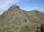
Views from the Apache Trail (click any image to enlarge):

Hike review: Phoenix South Mountain, Lost Ranch – National – Pyramid


When skiers use the phrase “earn your turns” they are talking about hiking to a snow-covered section of mountain that cannot be accessed by a chairlift in order to ski it. The phrase that kept coming to me during this hike was, “earn the burn.” As in, burn in the legs.

Let me remind you, I am hiking the trails of neighboring South Mountain to get my legs in shape for a May 2014 hike to the bottom of the Grand Canyon, and back out. If you’re looking to get your legs in shape, burn is good – and so is this hike.

I have not verified this point yet, but I would be willing to bet that this is the only trail in Arizona that leads you through a window of a burnt down structure, as you seen in the pictures below. This spot is known as Lost Ranch. It’s about a mile into the hike from the trail head, and where all the fun begins.

From here, you hike down through a pretty deep wash, then it’s all uphill for about another mile until you connect with National Trail. At this point, you hook a right and head east on National until it connects with Pyramid Trail about four miles later. If you’re in for a little more elevation gain, take an extra ten minutes and hike up Goat Hill for an outstanding view in all directions from 2,504 feet above sea level.

When I hiked it (January 2014), I did not encounter another person on that entire stretch. Once you connect to Pyramid Trail, you do a virtual about-face and head west about 1.5 miles before reaching what many consider the top of the trail.

Here is where I discovered my first petroglyph on South Mountain. I hear there are numerous petroglyph sites scattered throughout the park.

Petroglyph near the top of Pyramid Trail

Speaking from experience, the descent down the face of Pyramid Trail can be challenging, but nowhere near as tough as the hike up it.

Hike details:

  • Trail: Lost Ranch – National – Pyramid
  • Length: 9 mile loop
  • Time: 3.5 hours
  • Elevation gain: negligible
  • Difficulty: 1,270 (includes Goat Hill)
  • Date hiked: January 11, 2014

*Rough estimates. I don’t do GPS.

Hike review: Phoenix South Mountain, Sidewinder – Secret Trail Loop


The Sidewinder – Secret Trail loop is one of the easiest, yet most rewarding, trails I have hiked on South Mountain.  I estimate that the hike is about 2 miles round-trip and there is very little elevation gain. I intentionally chose this trail because I only had about an hour so before sunset and knew it would not take long.  The loop took me just over an hour to complete.

I found that the Secret Trail section of this hike was most intriguing since it runs along the desert floor, just at the foot of South Mountain.  From the trail, you can see a rocky crag rising up sharply toward the peak. I looked briefly for some of the fabled petroglyphs that are legend to exist in these parts, but I did not see any.  Closer examination would have required going off the trail.

I would recommend this trail for anyone who is looking for an be easy trail with spectacular views. Take a look at my pictures to get a taste of what the trail offers.  The trail head is located in a residential neighborhood near 36th Street & South Warpaint Drive.

Hike details:

  • Trail: Sidewinder – Secret Trail
  • Length: 2.0 miles round-trip*
  • Time: 1.0 hours
  • Elevation gain: negligible
  • Difficulty: easy
  • Date hiked: January 9, 2014

*Rough estimates. I don’t do GPS.

Check out the pictures and captions below for more insights. Click on pics to expand.

My new year’s resolution: Dropping the F-bomb


I know what you are thinking.  Why would anyone want to make using the F-word a resolution?  That’s just it: I don’t want to start using the F-word. I want to drop it from my vocabulary altogether. Image

For many of you, this may sound like a trivial resolution.  However, use of the F-word has become all too commonplace for me.  Although few people in my social circles have heard me use the F-word, it has become a word I rely on far too frequently in my vocabulary – especially when I’m alone.

Many times, I use it only when I’m talking to myself, such as when I’m driving or going about my work day. I use it as a noun, a verb, an adjective, a pronoun, and often as a complete sentence.

It always sets me back when I hear somebody that I respect otherwise, drop the F-bomb in the course of conversation.  One day, it occurred to me that others probably have similar reactions when I use it. And if negative talk has any impact on moods (I believe it does), then I might be able to improve my overall mood by nixing the F-word.

In any case, the word is never used to express anything positive when it comes out of my mouth. My hope is to eradicate it from my lexicon altogether, since it does not benefit me in any way. Effective immediately, I will cease to use the F-word.

Hike review: Desert Classic Trail on South Mountain in Phoenix, AZ


I continued my quest to hike every foot of charted trail on South Mountain by hiking a portion of Desert Classic Trail with my 12 year-old daughter on Christmas Eve morning in 2013. She had recently hiked it with her 7th grade class, so I asked her to lead the way.

The highlight of the hike was a rest stop on the notorious helicopter pad, which is the highest point on the trail. We walked the perimeter of the helipad and admired the views of million dollar homes, mountains, and clear blue skies. We could even see my daughter’s school where we parked the car.

Desert Classic is appropriately named since it offers a great variety of desert terrain and plant life in a relatively short distance. I found the vegetation to be more noticeably dense and diverse than on many of the trails of South Mountain.

Hike details:

  • Trail: Desert Classic
  • Length: 3.5 miles round-trip*
  • Time: 1.5 hours
  • Elevation gain: 100 ft.*
  • Difficulty: moderate

*Rough estimates. I don’t do GPS.

Check out the pictures and captions below for more insights. Click on pics to expand. One of these days, I’ll add highlighted maps showing the exact trail(s) I hiked.

3 things every indie author can learn from Walter Swan


There is a lesson all of us would be independent authors can learn from Walter Swan.

I met Swan in December, 2013. Not in person. That would be tough since he passed away in the 1990s. I picked up an autographed copy of Swan’s book “How to be a Better Me” at a Goodwill store in Tempe one evening. When I first saw the book, I couldn’t help thinking, “There is no way somebody could market a book like this” and “If this guy can sell a book, so can I.”

You know the old saying: You can’t judge a book by it’s cover. That was certainly true with this book.

Image of book: How to be a Better Me
How to be a Better Me, self-published book by Walter Swan

I cracked open the book to get a taste of the author’s style. What I discovered intrigued me: Short chapters of two to three pages with lessons on how to be a better person, written in the language of a good ole boy. I plunked down my dollar-fifty for the book, zipped over to the nearest Starbucks and dug in. Walter had me hooked. I felt like my grandpa was telling me these stories.

After reading the book for a few days, I decided to Google the author and find out more about him. (You should too.) Swan was a retired plaster contractor in southeastern Arizona with no higher education and no prior experience as an author. He couldn’t find a publisher to pick up his book, so he decided to publish it himself, with the help of a printer in Tucson, AZ.

Only a few stores would put his book on their shelves, so he rented retail space in downtown Bisbee, AZ and opened a store to sell his book. He called the store “The One Book Store.” Any guess as to what he sold in that store? It wasn’t the book I picked up. His first book was titled, “Me n’ Henry .” Turns out “How to be a Better Me” was one of many he went on to publish, although it’s hard to pin down all his titles. One person blogged about meeting Swan in 1994 and mentioned he had sold over 35,000 copies. I’m not sure if that’s in reference to his first book or all books combined. Nevertheless, it’s an inspiring number.

Walter has inspired me not only to be a better person, but also to become an author. I have several book ideas and one book that’s about 90% written. I have been sitting on it for about three years since I didn’t feel like I have enough clout. Neither did Swan.

What independent authors can learn from Walter Swan:

  1. If you have good stories (and who doesn’t?), people will read them
  2. Previous experience is not required; nor is advanced education
  3. We don’t need the approval of a publisher to publish a book

These days it’s easier than ever to self-publish books in electronic format with the help of sites like lulu.com and etsy.com. All we have to do is have a vision, a story to tell and the determination to follow it through. It’s that last item that Walter Swan has inspired me with.

Hike review: Phoenix South Mountain, Bursera – National Trail loop


Visible to anyone flying into Phoenix’s Sky Harbor Airport is South Mountain – a notorious mound of rock bearing a few dozen red-light dotted communications towers. Since one of the trailheads for South Mountain is about a half mile from my driveway, I have taken quite a few hikes on it since we moved to Phoenix in 2012.

It was only recently that I got serious with my goal to hike every foot of marked trail on South Mountain – a 17,000-acre preserve owned and operated by the City of Phoenix. Some sources report South Mountain (pdf map) is the largest city park in the nation. Who am I to question them? For a little perspective, Vail Ski Resort in Colorado measures up at 5,300 skiable acres.

I completed the hike chronicled below with my friend Ken on a beautiful Saturday morning in December, 2013. We were blessed with mostly cloudy skies following a day and a half of rain. We also had a few days of rain a couple weeks earlier, so the mountain was as green I have seen it.

Hike Details*

  • Trail(s): Bursera Trail to National Trail via Lost Ranch
  • Length: 5+ miles round-trip
  • Time: 3.5 hours
  • Elevation gain: 800 ft. (ballpark)
  • Difficulty: hard

*Rough estimates. I don’t do GPS.

Click photos to enlarge.

My Arizona Bucket List


Image of Grand Canyon
One of many lookout points along the south rim of the Grand Canyon.

I’m creating this list for my family and me, but thought I’d share it for anyone else who might be interested. We just moved to AZ in 2012.

I became aware of many of these sight from the Arizona Highways Magazine TV show and Facebook page. If there are other sites you would recommend, please leave them in the comments box below.

Must see:

  • Chiricahua Mountains
  • Grand Falls, aka Chocolate Falls
  • Sunrise Ski Resort
  • Lake Powell
  • Petrified Forest
  • Rooster Cogburn Ostrich Ranch (don’t judge 🙂 )
  • Sabino Canyon
  • Saguaro National Park
  • Meteor Crater
  • Town of Winslow

Have seen:

Enjoy!

Reflections on my hike of Cholla Trail on Camelback Mountain


I’ve been prepping myself for a 3-day hike in the Grand Canyon in May 2014 by taking on some of the more strenuous trails around Phoenix. Camelback Mountain has a reputation for setting the legs on fire, so when I saw that my church had organized a hike up the humps the first weekend of December, I couldn’t pass it up. Below is a quick summary of my experience.

At the time of our hike, the only way to access the top was via Cholla Trail (pronounced choy-ya) which rises up from the east side. In the picture below, envision hiking a trail cut just on the other side of the spine of the camel that runs from the right (or rear) to the left.

Image

Quick stats:

  • Destination: Camelback Summit – the top of the tallest hump in pic above
  • Distance: about 3 miles round trip
  • Elevation gain: 1,300 feet
  • Time: 3.5 hours; time of day: early morning
  • Weather: sunny with calm air and temps in the mid-50s

Likes:

  • Free admission
  • Views from the top and other vantage points
  • Desert landscape
  • That burn in the legs

Dislikes:

  • Parts of trail require scaling rock walls and navigating back down them
  • Concern of bee attacks as advised by signs (bees killed a few people on Camelback in 2013)
  • Volume of other hikers on the weekend resulted in congestion
  • Parking a half mile from the trail head on a residential street

Conclusion
I’m glad I hiked Camelback so that I can say that I’ve done it, but I won’t be rushing back anytime soon. The single biggest turnoff was the volume of people. Friends have recommended other trails that will help prep me for my Grand Canyon hike, so I’ll place priority on those trails in the future.

If you have hiked Camelback, I would like to hear your thoughts in the comment box below. Questions? Fire away and I’ll do my best to answer them.

Some more pics from my hike (click to enlarge)…

Tempe, Arizona Ironman Triathlon 2013


I heard that the Ironman Triathlon competition was being held in nearby Tempe today, so I had to have a look.

I remember watching highlights from the Ironman in Hawaii on ABC’s Wide World of Sports when I was a kid. The graphic images stick with me today of people crossing the finish line and having virtually no control over their muscles after a day of grueling exercise consisting of a 2-mile swim followed by a 112-mile bike ride, followed by a 26.2 run (i.e. marathon). Today I witnessed it in person.

The Tempe course is great for spectators because you can see the athletes at numerous points in their journey, such as the start and end of the swim and bike ride, plus the run portion at the 4-, 12- and 26 mile points. Hat’s off to these amazingly driven individuals.

Here are some photos I took. Plenty more of professional quality at http://www.ironman.com.